
Home

  • Twitter
  • Instagram
  • LinkedIn
  • YouTube
  • Facebook
  • About Us
    • Department Overview
    • People
    • Administration
    • Resources
    • Emergency Preparedness
  • Undergraduate
    • Prospective Students
    • Advising
    • Courses and Facilities
    • Special Programs
    • Graduation
    • Internship and Career Exploration
  • Graduate
    • Prospective Ph.D. Students
    • Master of Science and Graduate Certificate Programs
    • About Our Ph.D. Students
    • Resources
  • Research
    • Geospatial-Information Science and Remote Sensing
    • Human Dimensions of Global Change - Coupled Human and Natural Systems
    • Land Cover - Land Use Change
    • Carbon, Vegetation Dynamics and Landscape-Scale Processes
  • GIS
    • Center for Geospatial Information Science
  • Alumni
    • Faculty: A Historic Look
    • The Department of Geographical Sciences Alumni
  • Diversity
    • Land Acknowledgement
    • Diversity, Equity, Inclusion & Anti-Racism in GEOG
    • Beyond GEOG: Resources and Learning
    • GEOG and UMD Reporting Mechanisms
  • High School Hub
    • Program Overview
    • High School Awards
    • High School Internship Program (HIP)
    • GIS Day
    • Terp Young Scholars Summer Program
Enter the terms you wish to search for.

MS GEOINT Program Receives Accreditation from USGIF

Fjallsárlón, SE Iceland - May 2018

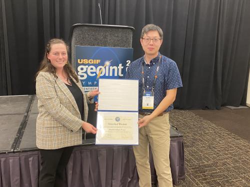
The United States Geospatial Intelligence Foundation (USGIF) recently announced the Master of Science in GEOINT (MS GEOINT) at GEOG-UMD has earned USGIF Collegiate Accreditation.

“The University of Maryland has produced many GEOINT community leaders,” said USGIF CEO Ronda Schrenk. “Through these accreditations, we will help foster the next generation of trailblazers.”

“We are thrilled that our master’s program has received the second accreditation from USGIF after the accreditation of our graduate certificate program in 2018,” said Dr. Ruibo Han, CGIS Director of Programs, Senior Lecturer, MPS GEOINT Program, UMD. “This recognition validates the quality of our program and opens new opportunities for our graduates in geospatial intelligence.”

UMD’s Master of Science in Geospatial Intelligence (MS GEOINT) program provides workforce-focused technical training that gives graduates the skills and expertise to lead new initiatives in the rapidly shifting landscape of GEOINT applications, data collection systems, analytic methods and mission support. The MS GEOINT program encompasses a 30-credit (10 units of 3-credit courses) structure consisting of five core courses and five elective courses that can be taken on a flexible schedule. The MS GEOINT degree can be completed in as little as 15 months for full-time registrants.

The GEOINT program was constructed and evaluated with the GEOINT Essential Body of Knowledge, which provides a blueprint for institutions to follow to ensure that students are well-equipped for the evolving GEOINT field.

Learn more about USGIF’s Collegiate Accreditation program.

Press release by Brad Causey, senior director of communications at USGIF, with collaboration from Renata Johnson, GEOG outreach coordinator

About USGIF 

USGIF is a nonprofit educational foundation dedicated to promoting the geospatial intelligence tradecraft and developing a stronger GEOINT community among government, industry, academia, professional organizations, and individuals who develop and apply GEOINT to address global security challenges. USGIF achieves its mission via its strategic pillars: Build the Community | Advance the Tradecraft | Accelerate Innovation.

Image: COL [R] Steven D. Fleming, Adjunct Professor of the Practice of Spatial Sciences and Institute for Creative Technologies at the University of Southern California
 

USGIF CEO Ronda Schrenk and Dr. Ruibo Han, CGIS director of programs

Department of Geographical Sciences
University of Maryland, 2181 Samuel J. LeFrak Hall, 7251 Preinkert Drive, College Park, MD 20742
Phone: 301-405-4050  ♦ Contact Us

  • College Directory
  • Give to GEOG
  • Alumni
  • UMD Web Accessibility
University of Maryland 1856 - College of Behavioral & Social Sciences

Login / Logout